
Before the Tour
The official travel portal for Norway - find out more about sights, accommodation and travel destinations. Ideal for getting an overview:
Visit Norway
"Statens vegvesen" (the Norwegian Public Roads Administration) is the Norwegian state authority responsible for the construction and maintenance of national and county roads, as well as supervision of motor vehicles and traffic in general. On their website you can read about road closures, blocked passes and planned opening dates. Webcams show real-time road conditions and there's a lot more on the site too. Very good to use before the day trips. The site is only available in Norwegian, but with the Google Translate function in the browser, you can easily find your way around:
Vegvesen
Facts
Norway has approx. 5.4 million inhabitants on approx. 385,000 km² of land. That comes out to 14 inhabitants per square kilometer. (In the USA for example it's 33 pro km²).
Away from larger cities, the country is rather sparsely populated, so there are hardly any cafés to stop at when you're on a journey. You should also plan your gas station stops, especially before venturing into remote areas. Roads are consistently in good condition, but pay attention to the speed limits. Speeding tickets are expensive. Eating, drinking and refueling are also expensive compared to most other countries.
We booked hotels through a well-known booking platform. Most of the hotels are payable 24 to 48 hours in advance and can be canceled free of charge. This offers good flexibility if changes are required.
It's worth registering via various apps in order to be able to conveniently and automatically pay for ferry journeys (within Norway), parking in large cities and tolls on a few roads. Usually, these fees cannot be paid by cash or credit card.
The Journey
We drove from Germany with a trailer to Hirtshals (Denmark) and stayed in a hotel before boarding the ferry. You can leave the motorcycle trailer there for a low cost.
From Hirtshals the ferry goes to Kristiansand, the start and end point of our tour.
We decided on Colorline and were very satisfied. The mopeds are lashed for the crossing. Belts are available in sufficient numbers (in the main travel season you could still put two in your bag). An alternative would be a ferry ride from Kiel to Oslo.
If you check-in in the evening, you can cross at night and arrive in Oslo in the morning.
The Tour
Details:
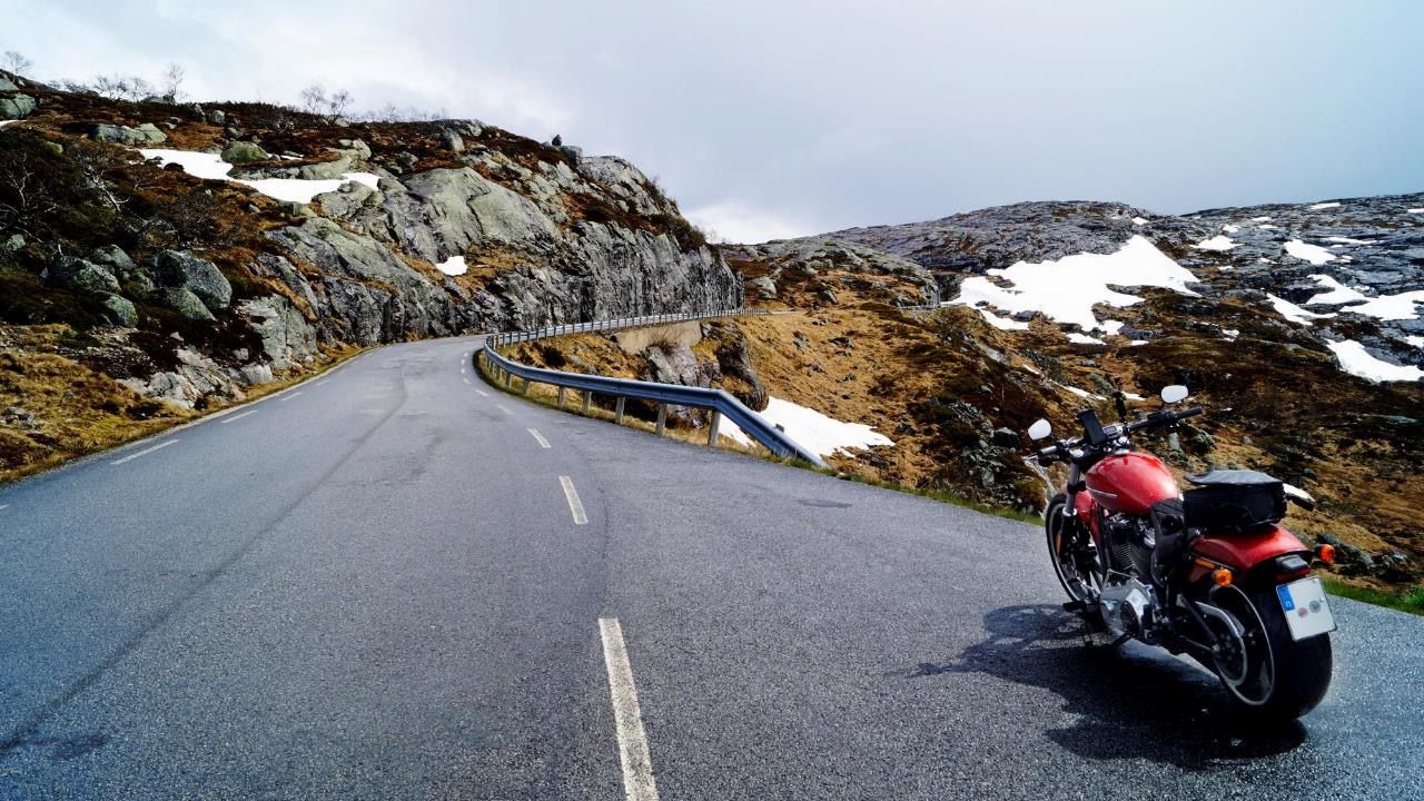
- Tour: from Kristiansand via Haukeliseter, Flåm to Åndalsnes and Krisitiansund, further via Otta to Oslo and back to Kristiansand
- Travel time: end of May to June 2022
- 200 km to 330 km per day
- Total distance: approx. 2500 km with 11 overnight stays in Norway
- Planned completely with calimoto via browser. Tours divided into day tours or half-day tours
- Tours followed via smartphone, everything functioning without problems
- Overnight stays all booked before the trip
NORWAY: Day 1
TOUR DURATION: approx. 3h
DISTANCE: approx. 170 km
ROADBOOK
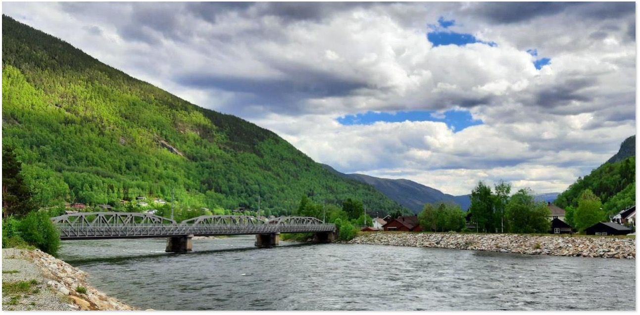
Arrived by ferry in Kristiansand, take the E 18 / 471 towards Gimlekollen - then onto the 452. At Ålefjær turn left onto the 3912 - then right onto 3746 - left onto 3750, which becomes the 405 after Oggevatn. At Engesland turn left onto the 3766 which becomes the 3772 on the right.
In Evje turn right onto the 9. In Byglandsfjord on the 3778 keep left of the fjord - change over the water to the 3804 until just before Ose.
→ Reiårsfossen
Back to Ose on route 9 to Rysstad.
ACCOMMODATION: Hotel Solvgarden, Rysstad
NORWAY: Day 2-1
TOUR DURATION: approx. 3h
DISTANCE: approx. 140 km
ROADBOOK – Detour Fjord Lysebotn
From Rysstad continue on 9 and then left take 450 towards Lysebotn - turn right onto 4224 and then to the viewpoint - 27 hairpin bends to Lysebotn fjord - back via 4224 and 450 onto 9.
→ Lysebotn Fjord
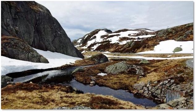
Lysebotn Fjord is an impressive fjord in Rogaland. Several of the mountains rise 1000 meters above sea level. The road was officially opened in 1984. Before then, the waterway was the only connection to the outside world for the residents of Lysebotn.
The way back from Lysebotn leads through a 1100-meter-long tunnel. Then the road meanders over 27 sharp hairpin bends up into the high mountains. The highest point is at Lake Andersvatnet (950 m). The road is open from late May to October.
NORWAY: Day 2-2
TOUR DURATION: approx. 2.5 hours
DISTANCE: approx. 130 km
ROADBOOK
From Rysstad stay north on 9, turn left onto 3810, back onto 9 and then turn left onto 3808 at Dalevegen. Back on the 9 and then right around the lake at Trydal towards Bykle.
→ Sarvsfossen reservoir
The dam is 50 m high and 150 m wide. It dams the river at Sarvsjuvet by 40 m. The capacity of the dam is 600,000 cubic meters.
Cross the bridge over the reservoir in the direction of Stavenes (otherwise stay on 9) and back on the 9 in the direction of Dalen, turn right in Haukeli in the direction of Haukeliseter to the hotel.
ACCOMMODATION: Hotel Haukeliseter Fjellstue
NORWAY: Day 3-1
TOUR DURATION: approx. 2.5 hours
DISTANCE: approx. 140 km
ROADBOOK
Depart from hotel and continue on E134. Leave E134 on the right at Ulevåvatnet lake, stay there and cross E134 to drive along Dyrskar Turistveg. Then turn left onto the E 134. In the village of Røldal turn left at the
→ Røldal stave church
and make a photo stop. Turn left back onto the E 134, keep right and possibly take the Håra curves with you. Just before Skare turn right onto the 13. After Skare comes the next highlight:
→ Latefossen
Continue on route 13 towards Hildal and turn right past the lake Sandvevatnet to Odda. In Odda stay right on the 13 and drive via Tyssedal and Lofthus. The 13 takes us to the left over the Hardanger Bridge
→ Hardangerfjord
We turn left to Granvin and drive to the Hardangerfjord as far as Eide.
EXCURSION to Kvanndal and back.
HIGHLIGHTS:
→ Røldal stave church was built around 1200. In the Middle Ages, Røldal was the second most important place of pilgrimage in Norway after Nidaros Cathedral and continued to be a place of pilgrimage thereafter until 1835.
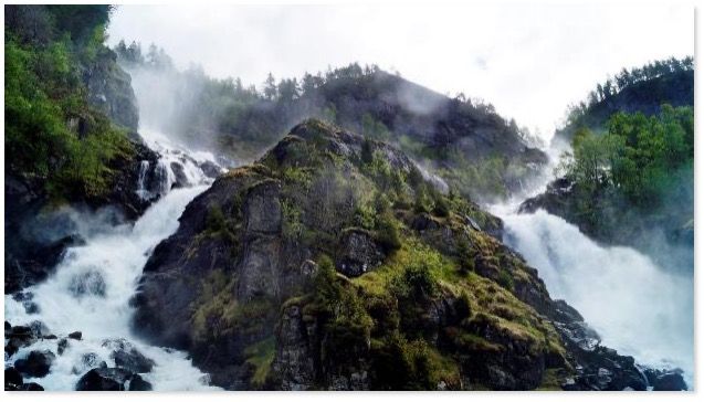
→ Låtefossen: the twin waterfalls Låtefossen in the Odda valley has a drop of 165 meters and has been a popular travel destination since the 19th century. Låtefossen waterfall is easy to get to, it is just off main road 13 between Odda and Røldal.
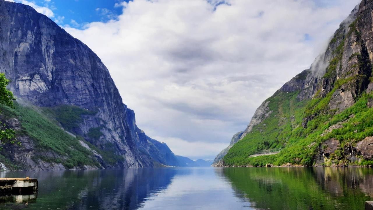
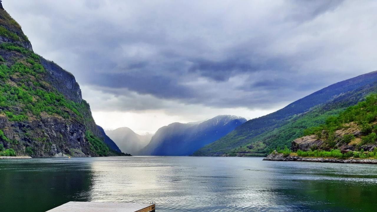
→ Hardangerfjord The 179 km long Hardangerfjord (second longest fjord in Norway) lies in a landscape that leaves even well-travelled tourists speechless.
NORWAY: Day 3-2
TOUR DURATION: approx. 2h
DISTANCE: approx. 110 km
ROADBOOK
From Granvin go back on the 13 and turn right past Granvinsvatnet Lake (do not take the tunnel!). On the way lies the waterfall:
→ Skjervefossen
Back on the 13 towards Vossevangen and make a small detour via the village of Vossevangen by the Vangsvatnet lake. From there first drive towards Borstrondi/Skjerre, a short stretch on the 13/16, then turn right towards Kvitheim onto the 5390 and drive past Lønavatnet on the right. Turn right onto 13/16. Shortly afterwards the waterfall is on the left:
→ Tvindefossen
Via Vinje, at the beginning of Oppheimsvatnet lake, we leave road 13 to turn right onto road 5404. After the lake we meet road 16 again. Shortly after that, turn left via Stalheimskleiva.
In Gudvangen there is the next highlight:
→ Kjelfossen waterfall
Continue on route 16 through the Gudvanga Tunnel (very long and impressive, with a roundabout!) to get to Flåm.
ACCOMMODATION: Hotel Flåmsbrygga
NORWAY: Day 4-1
TOUR DURATION: approx. 2.5 hours
DISTANCE: approx. 120 km
ROADBOOK
Departing from the hotel in Flåm, turn right onto E 16 and stay right along the Aurlandsfjord. Before Aurlandsvangen, turn left onto 5627 (do not take the tunnel). We wind our way up to the Stegastein viewing platform:
→ Stegastein
Then it's on towards Lærdal via Aurlandsfjellet.
FERRY → from Fodnes we cross the fjord by ferry to Mannheller.
→ Detour to Gaupne (and back)
In Sogndal we turn right onto the 55 to Gaupne. From there we see the waterfall:
→ Feigefossen
NORWAY: Day 4-2
TOUR DURATION: approx. 1.5 hours
DISTANCE: approx. 85 km
Take the same route back and in Sogndal turn right and take the 13.
The waterfall is on the way to Hella:
→ Kvinnafossen
On to Hella.
FERRY → from Hella to Dragsvik
In Hella we take the ferry to Dragsvik. From there it is only a short walk to Balestrand.
ACCOMMODATION: Hotel Kviknes Balestrand
NORWAY: Day 5
TOUR DURATION: approx. 3h
DISTANCE: approx. 130 km
ROADBOOK
From Balestrand via Dragsvik on 613 towards Vik along the side arm of the fjord to the viewpoint:
→ Gaularfjellet
Continue towards Vik, then past Lauvavatnet Lake. On the way lies the waterfall:
→ Vallestadsfossen
After the waterfall comes the Haukedalsvatnet lake. Turn left towards Vassenden and later right onto the E39 towards Vassenden. In Vassenden turn left onto 5690 and right along Jølstravatnet.
Before Skei, drive towards Skei over the Kjøsnesfjord bridge.
ACCOMMODATION: Skei Thon Hotel
NORWAY: Day 6-1
TOUR DURATION: approx. 2h ROUTE: approx. 120 km
ROADBOOK
Departure from Hotel Thon in Skei on E 39 towards Utvik at Innvikfjorden.
In Byrkjelo take the 60 towards Utvik.
Turn right and drive along the Innvikfjorden to Stryn.
There take the 15 towards Hjelle. In Hjelle we see the
→ Glomnesfossen waterfall
Back on the 15 we took from Stryn, continue on the 15 to turn onto the 258. Photo stop at:
→ Videfossen
NORWAY: Day 6-2
TOUR DURATION: approx. 3.5h ROUTE: approx. 180 km
ROADBOOK
After the break at Videfossen continue on the 258. At lake Breiddalsvatnet in Grotli turn left onto the 15 towards Geiranger. Before Langvatnet lake turn right on 63 and then along the lake and later at Djupvatnet lake (Both lakes are on the left side). At the end of Djupvatnet turn right a
DISTURB:
→ Dalsnibba (1,500 m).
Turn right back onto the 63 to Geiranger. There we take a break. Short detour towards Homlong; possibly visit Seven Sisters Waterfall, where there are several viewpoints.
→ Geiranger / Ørnevegen
Continue on the 63 towards Eidsdal. Before the ferry, possibly a short detour to Norddal.
Ferry → from Eidsdal to Linge.
Turn left onto 650 and continue towards Valgermo. Turn right onto E136/E39 and drive through to Åndalsnes.
ACCOMMODATION: Grand Hotel, Åndalgata 5, Åndalsnes
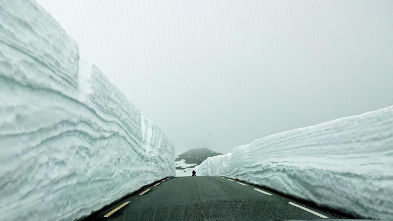
Alternative: After the ferry turn right towards Valldal. Possibly a short detour to Fjørå. On the 63 further Trollstigen and Åndalsnes. Note: due to an avalanche, the Trollstigen was not passable throughout.
The Eagle Road is about 8 km long and has a gradient of up to 10%. Especially the southern climb from Geirangerfjord is one of the most impressive bike routes in Norway. It winds in eleven serpentines from sea level up to Korsmyra at 620 m, where impressive views of the Geirangerfjord with its waterfalls, as well as the town of Geiranger can be seen again and again.
NORWAY: Day 7
TOUR DURATION: approx. 2,5h ROUTE: approx. 140 km
ROADBOOK
Åndalsnes - in Åndalsnes turn right onto the 64, then around the Romsdalsfjord (the fjord is on the left). Continue on 64 towards Åfarnes until you reach the ferry.
Ferry → from Åfarnes to Sølsnes
Continue on 64 north across the Fannefjord. At Moen, turn left onto Syltevegen towards Farstad on the 663. Then back onto the 64 via the
→ Atlantic Road
as far as Kristiansund
NORWAY: Day 8
TOUR DURATION: approx. 3h ROUTE: approx. 170 km
ROADBOOK
From Åndalsnes turn right on E 136 towards Otta. Several waterfalls are on the route, e.g. Slettafossen is on E 136 Turn right at Lesja onto 2660.
→ Lesjaverk Kyrkje
From there, short detour to Dombås and left back onto 2660 continuing towards Otta, parallel to E6. A short stretch on the E6 follows. At Dovre, cross the E6 to the left and turn onto the 2656. After a short stretch on the E6, turn left and take a detour to
→ Høvringen
take a detour. Continue left on the E6 to Otta. Then turn right to Sel and continue on the 2614 to Otta.
ACCOMMODATION: Hotel Thon, Otta (alternatively in Lillehammer).
NORWAY: Day 9-1
TOUR DURATION: approx. 3,5h ROUTE: approx. 180 km
ROADBOOK
Depart Otta towards Lillehammer and cross the Otta river towards Sjoa on the 2600. We keep to the right of the river Gudbrandsdalslågen. In Sjoa continue on the 2598 towards Vinstra.
→ Stave church Vinstra
Continue on 2532 towards Lillehammer and always keep right of the river. Cross the river into Ringebu for the next photo stop:
→ Ringebu Stave Church
Continue on the 2532 towards Lillehammer. At Fåberg take 2532 and at Lillehammer take 2540 towards Gjøvik, keeping right of Lake Mjøsa.
Break in Gjøvik (alternatively in Lillehammer).
HIGHLIGHT Ringebu Stave Church:
Ringebu Stave Church dates back to 1220 and is one of the oldest of the 28 remaining of its kind. The church is located in Ringebu in the Gudbrands valley about 60 km north of Lillehammer.
This distinctive stave church was built around 1220. Around the year 1000, Norway's Christianization took place and in the years that followed, about a thousand stave churches were built.
During the renovation of the original church in the 17th century, the bright red tower was added.
Ringebu Stave Church is located in the middle of hills and farmland and is surrounded by a cemetery with beautiful and well-kept grounds.
NORWAY: Day 9-2
TOUR DURATION: approx. 3h ROUTE: approx. 140 km
ROADBOOK
Continue from Gjøvik on road 33 (away from the lake, not along the water) and after approx. 4 km turn left onto road 2368 towards Raufoss. Drive through Raufoss. Follow 4 towards Eina for a while. There turn right on 2380 to drive right along the lake Einavatnet. At the end of the lake, rejoin 4. Before Jaren, turn right onto 2324 and drive right around Jarenvatnet lake. Continue to Gran via 4 (tunnel), turn right onto 2300. Continue along the 4 to Harestua. Pass Harestuvatnet lake on the left. Join the 4 for a short distance and turn right to Hakadals. Cross the 4 again to the left and drive to Rotnes. There turn left onto the 4. Continue towards Oslo until you reach the hotel.
ACCOMMODATION: Scandic Fornebu Hotel
NORWAY: Day 10
TOUR DURATION: approx. 8h
DISTANCE: approx. 14 km
Oslo without the bike ;-)


